


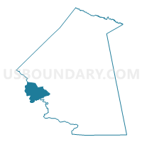
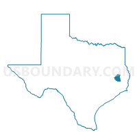
Voting District 0005, Polk County, Texas
About
Outline

Summary
| Unique Area Identifier | 676414 |
| Name | Voting District 0005 |
| County | Polk County |
| State | Texas |
| Area (square miles) | 34.69 |
| Land Area (square miles) | 11.66 |
| Water Area (square miles) | 23.03 |
| % of Land Area | 33.62 |
| % of Water Area | 66.38 |
| Latitude of the Internal Point | 30.71594500 |
| Longtitude of the Internal Point | -95.07942580 |
Maps

Graphs
Select a template below for downloading or customizing gragh for Voting District 0005, Polk County, Texas


Neighbors
Neighoring Voting District (by Name) Neighboring Voting District on the Map
- Voting District 0001, San Jacinto County, TX
- Voting District 0004, Polk County, TX
- Voting District 0006, San Jacinto County, TX
- Voting District 0007, San Jacinto County, TX
- Voting District 0007, Polk County, TX
- Voting District 0017, Polk County, TX
Top 10 Neighboring County Subdivision (by Population) Neighboring County Subdivision on the Map
- Livingston-Onalaska CCD, Polk County, TX (40,554)
- Coldspring CCD, San Jacinto County, TX (5,001)
- Point Blank CCD, San Jacinto County, TX (4,978)
Top 10 Neighboring Place (by Population) Neighboring Place on the Map
Top 10 Neighboring Unified School District (by Population) Neighboring Unified School District on the Map
- Livingston Independent School District, TX (27,301)
- Coldspring-Oakhurst Consolidated Independent School District, TX (13,347)
- Onalaska Independent School District, TX (7,173)
Top 10 Neighboring State Legislative District Lower Chamber (by Population) Neighboring State Legislative District Lower Chamber on the Map
Top 10 Neighboring State Legislative District Upper Chamber (by Population) Neighboring State Legislative District Upper Chamber on the Map
Top 10 Neighboring 111th Congressional District (by Population) Neighboring 111th Congressional District on the Map
Top 10 Neighboring Census Tract (by Population) Neighboring Census Tract on the Map
- Census Tract 2102.03, Polk County, TX (6,598)
- Census Tract 2002, San Jacinto County, TX (5,001)
- Census Tract 2003, San Jacinto County, TX (4,978)
- Census Tract 2102.04, Polk County, TX (4,102)
- Census Tract 2102.06, Polk County, TX (3,338)
- Census Tract 2102.05, Polk County, TX (2,482)